Search results
Create the page "MAP - Global Seismic Hazard Map (GSHAP, 1999).jpg" on this wiki! See also the search results found.
Page title matches
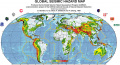
File:MAP - Global Seismic Hazard Map (GSHAP, 1999).jpg ...of Seismic Hazards from Global Seismic Hazard Assessment Program (GSHAP), 1999.(2,421 × 1,312 (1.18 MB)) - 03:31, 4 January 2018
.jpg)
.jpg&action=edit&redlink=1)
Page text matches
- ===Map of Average temperature anomaly (trend) for the past 30 years (North America ...nomaly Map shows the trend in warming / cooling for the past 30 years (1987-2016). This should be enough of a time to see the potential geographical dis11 KB (1,605 words) - 08:55, 10 April 2018
File:MAP - Global Seismic Hazard Map (GSHAP, 1999).jpg ...of Seismic Hazards from Global Seismic Hazard Assessment Program (GSHAP), 1999.(2,421 × 1,312 (1.18 MB)) - 03:31, 4 January 2018